 Nenyaki ©2008
 It has been an age and a day since I wrote on this blog. I could blame trying to get my thesis finished up (it is on track by the way) or numerous other things. OK, so I am going to blame my thesis after-all because it has been all engrossing and I haven’t really left my computer or thought about much else during this time!
But I have decided that it is time for me to escape the thesis induced black-hole and re-enter the world of my blog. I do happen to have a plethora of ideas to write on –the issues surrounding self-promotion in science or last month’s Alaska Marine Science Symposium, and minke whales could always do with more attention. But instead I have decided to start a series of blog posts entitled “Sunday Science Somethings”. I have adapted and borrowed the Sunday Something idea from my sister, who wrote a fun blog about all things pretty and beautiful. My adaptation will also talk about beautiful things, however, you will have to expand your definition of beautiful because I plan to share amazing, exciting, and fun science stories –most of which I suspect will be marine focused as that is my thing. But science itself is a beautiful thing so borrowing the title from my sister’s blog on beautiful things seemed appropriate –and as an added bonus she is happy to let me use it!
But I have decided that it is time for me to escape the thesis induced black-hole and re-enter the world of my blog. I do happen to have a plethora of ideas to write on –the issues surrounding self-promotion in science or last month’s Alaska Marine Science Symposium, and minke whales could always do with more attention. But instead I have decided to start a series of blog posts entitled “Sunday Science Somethings”. I have adapted and borrowed the Sunday Something idea from my sister, who wrote a fun blog about all things pretty and beautiful. My adaptation will also talk about beautiful things, however, you will have to expand your definition of beautiful because I plan to share amazing, exciting, and fun science stories –most of which I suspect will be marine focused as that is my thing. But science itself is a beautiful thing so borrowing the title from my sister’s blog on beautiful things seemed appropriate –and as an added bonus she is happy to let me use it!

This week has been full of fun, fascinating and significant science. Many scientists, science communicators and journalists converged on Chicago for the Annual American Association for the Advancement of Science (AAAS ) this week. My twitter feed has been filled with all sorts of interesting snippets’ –you can check some of these out by looking up #aaasmtg. But for me the most exciting science story to come up this week was that of study that has shown how it is possible to count whales from space. Yes, I did just write “count whales from space”. In fact the paper, published in PLoS One this week is entitled just that: Whales from Space: Counting southern right whales by satellite.
This might seem like a completely outlandish exercise to many, who on earth thought one could count whales from space? But as I saw links to the article appear in my twitter and facebook feeds and the story highlighted by the likes of the BBC, I remembered the time I was checking out the Beaufort Sea with Google Earth –I had a short lived moment of over excitement as I discovered what I thought was a whale’s tail fluke.... on a closer inspection in turned out to be boat. Needless to say the fact that scientists have now been able to show that high resolution satellite imagery (obviously Google Earth is not quite high tech enough. Yet.) can be used to count whales is utterly cool and I feel just a little bit vindicated for my Google Earth “discovery”.
This might seem like a completely outlandish exercise to many, who on earth thought one could count whales from space? But as I saw links to the article appear in my twitter and facebook feeds and the story highlighted by the likes of the BBC, I remembered the time I was checking out the Beaufort Sea with Google Earth –I had a short lived moment of over excitement as I discovered what I thought was a whale’s tail fluke.... on a closer inspection in turned out to be boat. Needless to say the fact that scientists have now been able to show that high resolution satellite imagery (obviously Google Earth is not quite high tech enough. Yet.) can be used to count whales is utterly cool and I feel just a little bit vindicated for my Google Earth “discovery”.
So how is it possible to count whales from space? And what are the practical uses for such methods? Or is it all just a bit of a news grabbing gimmick? First off, this is far from a gimmick. The implications for such a tool are widespread for both management and conservation of large whales. The methods presented in the paper provide the first successful attempt to use satellite imagery to count whales at and near the sea surface. Additionally, the authors attempts at automation means that whale counts can be made relatively efficiently and, importantly more quickly. The ability of this tool to help assess large areas for the presence of whales will provide an attractive alternative to the costly and risky aerial or vessel based surveys that are currently used for this purpose.
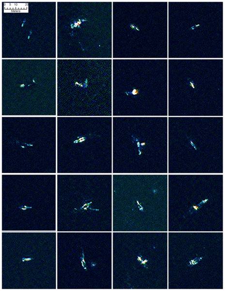
Figure 2 from Fretwell et al. 2014. A selection probable whales found by automated analysis.
One of the reasons that I am so excited about this paper is because I can see the potential for using satellite imagery to count whales in areas that are subject to human activities –such as oil and gas activities or commercial shipping. While this approach would not be an effective tool for real-time mitigation it could provide useful for baseline data on the presence of large whales in coastal areas subject to these human activities.
As with aerial surveys the methods presented in this paper can only count whales that are at or near the surface and so will always be subject to a bias –because whales only spend a small proportion of their at the surface. But with an understanding of how much time whales spend at the surface and how long they dive for we can try to overcome this bias. For aerial and ship based sightings this is achieved by calculating correction factors –essentially these are the probability that a whale will be at the surface when that patch of sea surface is in view of an observer. The number of whales detected in the survey –or image is then multiplied by this correction factor to give a better estimate of how many whales are actually present in the area. My thesis work has developed availability correction factors for aerial surveys that are recording bowhead whales in the Beaufort Sea and these methods could also be adapted to help correct the counts of whales achieved through the use satellite imagery. Essentially this idea of counting whales from space is advancing aerial survey techniques into the next sphere... the exosphere and even beyond that into space.
As with aerial surveys the methods presented in this paper can only count whales that are at or near the surface and so will always be subject to a bias –because whales only spend a small proportion of their at the surface. But with an understanding of how much time whales spend at the surface and how long they dive for we can try to overcome this bias. For aerial and ship based sightings this is achieved by calculating correction factors –essentially these are the probability that a whale will be at the surface when that patch of sea surface is in view of an observer. The number of whales detected in the survey –or image is then multiplied by this correction factor to give a better estimate of how many whales are actually present in the area. My thesis work has developed availability correction factors for aerial surveys that are recording bowhead whales in the Beaufort Sea and these methods could also be adapted to help correct the counts of whales achieved through the use satellite imagery. Essentially this idea of counting whales from space is advancing aerial survey techniques into the next sphere... the exosphere and even beyond that into space.
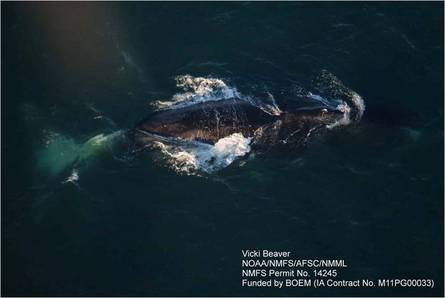
Bowhead whale in the Beaufort Sea. NOAA Marine mammal surveys 2012

 RSS Feed